I've been playing with the spatial support of SQL Server 2008 today, but quickly hit two obstacles:
- How do I get data into the database.
- How do I visualize a query (apart from the Well-Known Text output).
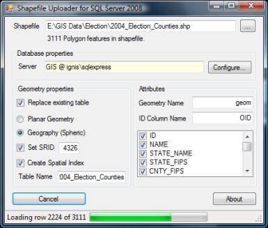
Surprisingly there aren't really any good (free) tools out there yet to upload for instance shapefiles to Katmai. I pulled out some old code I had lying around and threw a small tool together that can upload a shapefile to the database either as geometry or geography. Katmai is pretty picky when it comes to the geography datatype, so make sure your shapefiles contain valid geometry and has vertices in the valid domain, or use the geometry format. You can download the tool below.
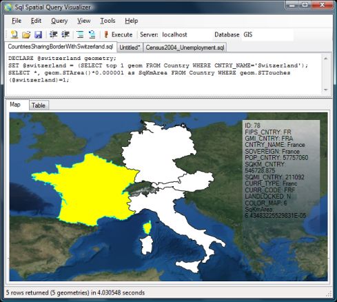
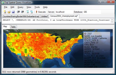
Next obstacle was visualizing the data. Playing with the spatial queries and not beeing able to see the results on a map quickly got boring. I haven't had a chance to play much with WPF, so I thought this was a good occation to play with it. Based on this MSDN article I managed to fairly quickly make a little tool that takes a SQL query as input and outputs the results in a WPF control. At the moment it only works with polylines and polygons - Points are simply ignored (tip: use STBuffer() on points to see them). It will look for the first column that contains a SqlGeometry or SqlGeography datatype and put that on the map. The remaining columns are shown in the box to the right when you hover over the shapes with the mouse.
The two tools are not perfect in any way (and there's no bug tracking support here :-)), but they provide a quick way to play with the spatial queries. Both tools requires Windows Authentification to access the sql server and runs on .NET 3.5. Furthermore the query tool uses the Microsoft.SqlServer.Types.dll that comes with installing Katmai (to parse the results), so for now you'll need to run it from a computer that has Katmai installed.
Read more and download SqlSpatialTools